Travel Guide
Understanding Jersey's Tidal Range: Low Tides, Seabed Walks, and Coastal Safety
Updated 26 October 2026

Few places on Earth experience a coastal transformation as radical or breathtaking as Jersey. Twice every day, the Atlantic ocean swells and recedes across vast granite reefs and golden sandy flats, completely redrawing the island's geography. At high water, the sea laps gently against harbour walls, seaside promenades, and towering cliffs. A few hours later, the ocean appears to drain entirely over the horizon, exposing an alien expanse of hidden reefs, sandbars, rock pools, and historic offshore fortresses.
For visitors arriving from mainland Britain or further afield, the sheer scale of the jersey channel islands tidal range can come as a genuine surprise. While it creates an incredible natural playground for walking, rock pooling, and marine discovery, it also demands deep respect. Navigating this ever-changing environment safely requires a clear grasp of how the tides operate, how rapidly water moves across flat ground, and what precautions are necessary before stepping out across the seabed. In this guide, I will unpack the fascinating science behind these extreme waters, explain how low tide transforms Jersey's coastline, and share practical safety advice for anyone planning to explore the intertidal wilderness.
The Science: Why Are Jersey Tides So High?
To understand the tides around Jersey, it helps to start with the fundamental mechanics that govern ocean waters worldwide. At their core, tides are the regular rise and fall of coastal seas caused predominantly by the gravitational pull of the Moon, with a secondary contribution from the gravitational attraction of the Sun. Because the Moon pulls unevenly across the globe—exerting its strongest gravitational tug on the ocean side nearest to it and pulling the Earth's solid centre away from the opposite side—two massive aquatic bulges are created in ocean basins across the planet.
As the Earth rotates through these gravitational bulges, coastal regions encounter a rhythmic cycle of rising and falling seas. Jersey and its neighbouring Channel Islands experience roughly two high tides and two low tides during each lunar day, which lasts approximately 24 hours and 50 minutes. This extra 50 minutes explains why high and low waters do not occur at the exact same hour each day; rather, similar tides advance by around 45 to 50 minutes from one afternoon or morning to the next.
The magnitude of the tide changes across the calendar month according to the relative orbital alignment of the Earth, Sun, and Moon. During periods of new Moon and full Moon, the Sun, Earth, and Moon align in space, pooling their gravitational forces. This alignment produces spring tides, which are characterised by the greatest difference between high and low water: the high tides reach significantly higher up the shore, and the low tides retreat much further down the seabed. Roughly seven days later, around the first and last quarter Moon phases, the Sun and Moon sit at right angles relative to the Earth. In this configuration, their gravitational pulls partially cancel each other out, producing neap tides with a much narrower vertical range.
While the celestial dance dictates the rhythm of the tides, local geography dictates their vertical scale. Jersey sits in the shallow, funnel-shaped waters of the Bay of Saint-Malo, tucked just 14 miles off the Normandy coast of France. When the vast Atlantic tidal wave travels into the comparatively shallow continental shelf of the English Channel and the Bay of Saint-Malo, that colossal mass of water becomes compressed. The sea is physically funnelled by the contours of the French coastline and the Channel Islands archipelago.
Compounding this funnel effect is the physical phenomenon of resonance. In marine physics, resonance happens when the natural rhythm or sloshing period of a coastal bay matches the timing of the incoming oceanic tidal wave. When these cycles synchronise, each incoming wave reinforces the momentum of the next, dramatically magnifying the wave's vertical amplitude. A helpful explanation of this dynamic can be found in the Jersey Tide Times scientific explainer, which details how ocean geography drives local water movement.
Thanks to this rare combination of shallow water compression, geographical funneling, and hydrodynamic resonance, the jersey tidal range ranks as the third largest in the world. On the biggest spring tides—often referred to locally as King tides—the vertical difference between low and high water can reach up to approximately 12 metres (nearly 40 feet). Jersey sits just behind Canada's Bay of Fundy (which reaches around 16 metres) and England's Bristol Channel and Severn Estuary (which can reach around 14 to 15 metres). This staggering jersey tide height means that millions of tons of water rush in and out around the island every single day.
The Vanishing Coastline: Jersey at Low Tide
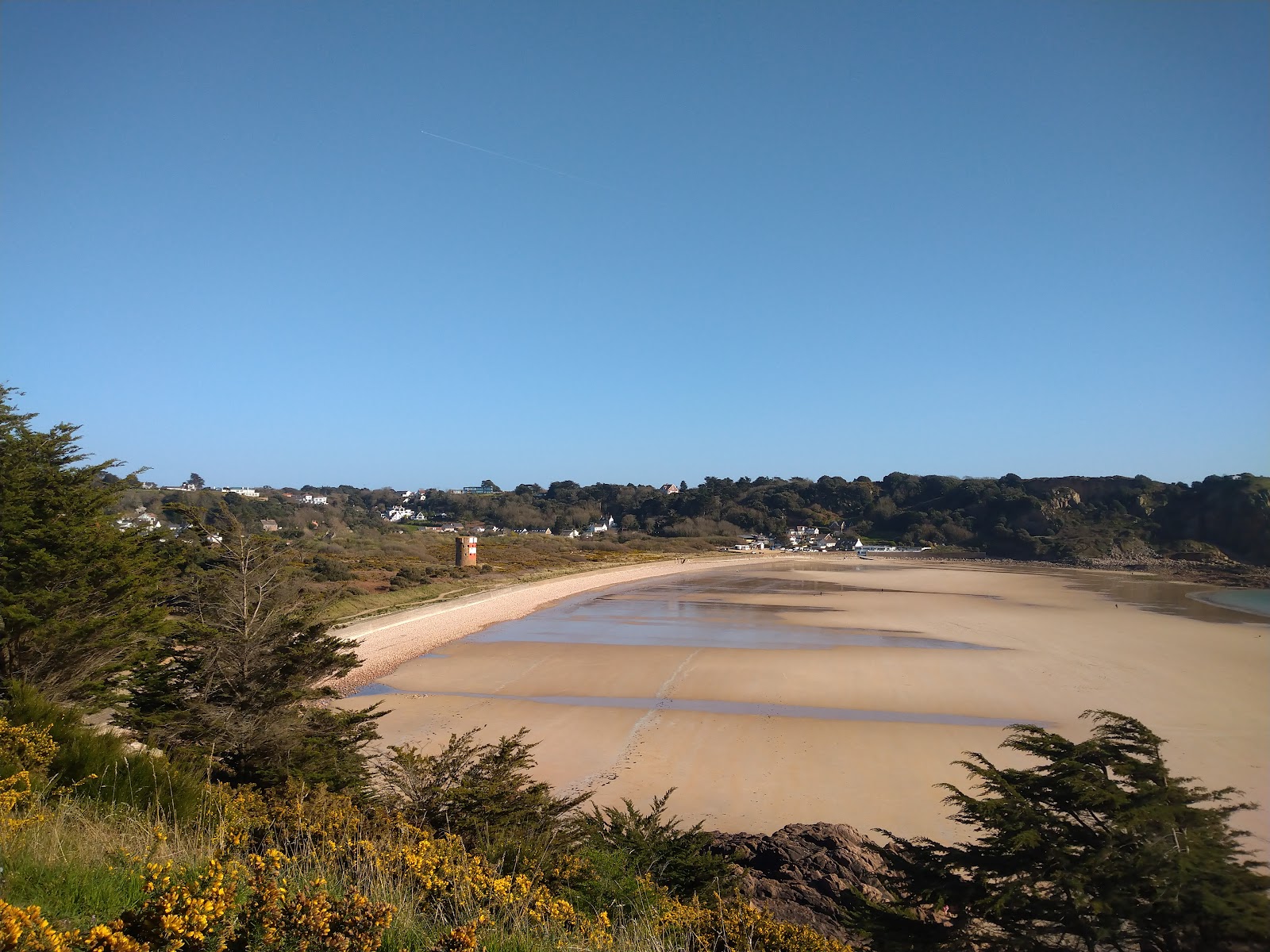
When the jersey tide out occurs, especially during a large spring tide, the island undergoes an astonishing physical metamorphosis. At lowest low water, the receding sea strips back the water in the Bay of Saint-Malo to expose approximately 120 square kilometres (about 45.5 square miles) of seabed. Because Jersey's standard dry land area is only around 118 square kilometres, this tidal drop practically doubles the geographic footprint of the island for a few short hours.
This immense intertidal expanse is unlike traditional sandy shorelines found in many other holiday destinations. It reveals a dramatic, labyrinthine terrain of jagged granite reefs, steep gullies, tidal gutters, hidden sandbanks, and sprawling lagoons. The rocky shore supports an exceptionally rich marine ecology, where cold Atlantic currents meet warmer southern waters to create a thriving home for hundreds of species of seaweed, shellfish, sponges, and fish.
Recognising the global significance of this marine ecosystem, four major coastal and offshore areas around Jersey have been formally designated as wetlands of international importance under the Ramsar Convention:
- The South East Coast: Extending continuously from La Collette in the south all the way to Gorey Harbour in the east. This constitutes the largest intertidal rocky zone in Europe and shelters extensive oyster and mussel beds.
- Les Minquiers: A vast offshore reef situated south of Jersey that features dozens of rocky outcrops and sandbanks exposed at low water.
- Les Écréhous and Les Dirouilles: A wild offshore archipelago situated to the northeast of Jersey toward France, known for seal populations and crystal-clear channels.
- Pierres de Lecq (The Paternosters): A treacherous group of granite rocks and reefs off Jersey's rugged northern coastline.
On the main island, you can see this landscape transform before your eyes across popular bays. Along the wide sweep of St. Helier Beach, the retreating sea opens up expansive flats overlooking historic fortifications. Around the southern corner in St Brelade, the low water connects adjacent coves; beachgoers can easily walk between the bustling bay of St Brelade and the quieter, wilder sand dunes of Ouaisne Bay. Over on the east coast, beaches like Anne Port Beach swap their gentle shingle margins for wide expanses of firm sand as the sea recedes toward the French coast.
Walking the Ocean Floor: Seabed Walks and "Moonwalks"
Because the jersey low tide walk experience is so unique, guided excursions out onto the exposed seabed have become one of the island's hallmark activities. Locals and visitors often refer to these treks across the southeastern Ramsar wetland as "moonwalks", owing to the stark, lunar-like appearance of the exposed granite reefs and boulder fields when the sea drops away.
These guided walks venture out into the Jersey Tidal Trail toward remote offshore landmarks that are completely surrounded by fathoms of water at high tide. The two most famous destinations are Seymour Tower—an 18th-century granite coastal defence tower standing more than two kilometres offshore—and Icho Tower, which sits isolated on an even lower reef accessible only during the biggest spring tides of the year. Walking to these sentinels across damp sandbanks, winding gutters, and knee-deep channels feels like stepping into another world entirely.
Specialist walking organisations, such as Jersey Walk Adventures and wildlife photographer Lou Wagstaffe's guided outings featured on Sea Hare Photography, run scheduled journeys across these flats throughout the year. These excursions range from gentle daylight rock pool rambles to late-night bioluminescence walks, where visitors search for microscopic marine organisms that sparkle like tiny fireflies across the wet sand after dark.
If you join a guided seabed exploration, you will notice that professional guides follow strict tidal rules. A well-planned intertidal walk will always follow the falling tide outwards from the shore, maintaining pace behind the retreating water. The guide will then schedule the shoreward journey to begin either at low water or very shortly after the tide turns. This window gives the group maximum safety clearance, ensuring they never have to race an incoming tide back across complex ground.
Because the intertidal zone is an ecologically sensitive marine habitat, visitors exploring the shore are expected to follow a strict Seashore Code:
- Watch your step: Tread carefully to avoid crushing delicate marine creatures, shellfish, and brittle seaweeds.
- Handle marine life with wet hands: If you find a crab, sea anemone, or starfish in a pool, only handle it with wet hands to avoid damaging its sensitive protective coating, and return it quickly to the exact spot where it was found.
- Replace turned stones: Always gently roll back any rocks or mats of seaweed you turn over while searching for marine life. The creatures living on the underside depend on that dark, damp shelter to survive until the sea returns.
- Respect coastal wildlife: Keep a respectful distance from roosting seabirds or resting marine mammals, and ensure domestic dogs are kept under close control.
- Leave no trace: Never leave litter behind, and actively collect and dispose of any plastic waste washed up on the reefs. Many operators are accredited under the UK-wide WiSe (Wildlife Safe) marine scheme to ensure disturbance is minimised.
Tidal Causeways and Coastal Landmarks
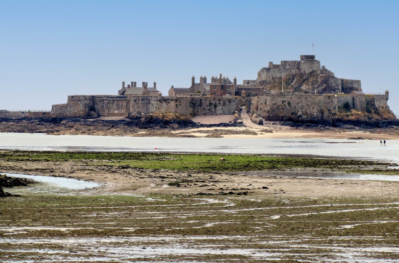
Beyond guided offshore moonwalks, Jersey is famous for its tidal causeways—natural rocky ridges or paved concrete paths that connect island forts and headlands to the mainland at low water. These sites are among the most photographed attractions on the island, but they are also common locations where unsuspecting visitors get cut off by rising water.
The four primary causeways monitored by coastal safety services include:
- Elizabeth Castle Causeway: Situated in St Aubin's Bay just off St Helier, the 16th-century Elizabeth Castle sits on a rocky islet. When the jersey tide range allows, visitors can walk out across the paved causeway directly from the seafront. As the water rises, the causeway quickly disappears beneath several metres of sea, at which point commercial amphibious craft take over ferry duties to transport visitors across the bay.
- La Corbière Causeway: Anchored at the island's extreme south-western tip, Corbiere Lighthouse (La Corbiere) stands vigil over notoriously jagged reefs. The lighthouse was lit in 1874 and was the first in the British Isles built from reinforced concrete. A concrete walkway across the rocks allows visitors to reach the base of the lighthouse during low tide. However, the reef fills from multiple angles as the tide pushes in. To protect visitors, an automated safety siren sounds loudly across the headland to warn pedestrians when the incoming tide is about to submerge the walkway, signaling that it is time to return to the mainland immediately.
- St Aubin's Fort Causeway: Perched guarding the harbour in St Aubin's Bay, St Aubin's Fort dates back to the 1540s. A causeway from the shoreline near the local yacht club allows pedestrians to walk out around the historic perimeter at low tide. Like Elizabeth Castle, the approaches can flood rapidly once the tide turns.
- The South East Coast to Seymour Tower: This is an unpaved wilderness route over natural sand, gravel, and rock gutters. Unlike concrete causeways, there is no defined path, making accurate tidal awareness and local knowledge essential.
The Rule of Twelfths and Coastal Safety Protocols
Why do people get caught out by tides jersey channel islands so frequently? The primary danger lies in a common misunderstanding of how the sea rises. Most people assume that if the tide takes roughly six hours to rise from low water to high water, it must rise at a steady, predictable pace of one-sixth of its total height every hour. In reality, the ocean behaves like a massive harmonic wave.
To estimate this non-linear movement, mariners and coastal navigators use a classic calculation known as the Rule of Twelfths. If you divide the roughly six-hour tidal flood into six equal one-hour stages, the water level changes by the following proportions of the total vertical range:
| Tidal Stage | Approximate Duration | Proportion of Total Tidal Rise |
|---|---|---|
| Hour 1 | 1st hour after low tide | 1/12 of total range |
| Hour 2 | 2nd hour after low tide | 2/12 of total range |
| Hour 3 | 3rd hour after low tide | 3/12 of total range (Fastest rise) |
| Hour 4 | 4th hour after low tide | 3/12 of total range (Fastest rise) |
| Hour 5 | 5th hour after low tide | 2/12 of total range |
| Hour 6 | 6th hour after low tide | 1/12 of total range |
The critical lesson of the Rule of Twelfths is that the water moves most slowly right around low and high water, but rushes in at peak speed during the middle two hours (hours three and four). In that middle period, half of the entire tidal range floods ashore in just two hours.
On a 10-metre spring tide in Jersey, that means the sea level rises by 2.5 metres (over eight feet) in hour three, and another 2.5 metres in hour four. Across flat sandbanks and rocky gutters, a vertical rise of just a few inches can translate into a horizontal surge of hundreds of metres of water across the seabed in minutes. Gullies and low troughs behind you can fill up with deep water long before the higher rock ridge you are standing on becomes submerged, silently cutting off your escape route to the shore.
It is also vital to recognise that published tide predictions are mathematical forecasts. As highlighted by the Ports of Jersey tidal guidance, actual water levels frequently diverge from published tables due to atmospheric conditions. Prolonged periods of intense high atmospheric pressure can suppress the surface of the sea, reducing the actual tide height, whereas strong onshore winds and low-pressure systems can push water higher and faster than the charts predict, causing variations of more than 0.5 metres from the tables.
To keep yourself safe when visiting Jersey's beaches and reefs, remember to check official local tide times specifically for the port you are visiting. Never venture deep into offshore reefs alone, and heed warning sirens at La Corbière without delay. If an emergency arises, the Jersey Coastguard advises calling 999 immediately or issuing a Mayday call on VHF radio channel 16.
Planning Your Coastal Days Around the Rhythms of Jersey
Once you understand how the tidal range channel islands system functions, the shifting sea becomes one of the most rewarding parts of visiting Jersey. Instead of planning your days around fixed clock hours, you can structure your adventures around the natural pulse of the sea.
Low tide is the ideal time for exploring expansive beaches, wandering through rock pools, crossing to tidal castles, or joining a guided seabed walk. High tide, by contrast, brings the deep blue ocean right up to coastal seawalls, creating perfect conditions for swimming in sheltered bays, sitting at harbour cafes to watch fishing boats return to their moorings, or taking scenic cliff walks along Jersey's rugged northern coast. By keeping a watchful eye on the tide tables and treating the ocean with respect, you can safely experience one of the most remarkable tidal landscapes in the world.
Cover photo: Jersey Walk Adventures
By Alyssa.
Sources and further information
- How the Tides Work: Spring & Neap Tides Explained · Jersey Tide Times
- Tides at St Helier | Ports of Jersey
- Sea Hare Photography | Intertidal Walks
- Home - Jersey Walk Adventures
- Jersey Coastguard | Ports of Jersey
- St. Helier Beach
- Corbiere Lighthouse (La Corbiere)
Sources checked: 2026-10-26.